Polygon
A polygon is a closed shape that defines an area with customizable stroke and fill properties. Polygons are useful for representing zones, regions, boundaries, or area-based features.
Composable Functions
@Composablefun Polygon( points: List<GeoPointInterface>, id: String? = null, strokeColor: Color = Color.Black, strokeWidth: Dp = 1.dp, fillColor: Color = Color.Transparent, geodesic: Boolean = false, extra: Serializable? = null)PolygonState( points: List<GeoPointInterface>, id: String? = null, strokeColor: Color = Color.Black, strokeWidth: Dp = 1.dp, fillColor: Color = Color.Transparent, geodesic: Boolean = false, extra: Serializable? = null)
@Composablefun Polygon(state: PolygonState)Parameters
points: List of geographic coordinates defining the polygon vertices (List<GeoPointInterface>)id: Optional unique identifier for the polygon (String?)strokeColor: Color of the polygon boundary (default:Color.Black)strokeWidth: Width of the boundary line (default:1.dp)fillColor: Fill color of the polygon interior (default:Color.Transparent)geodesic: Whether to draw geodesic edges (default:false)extra: Additional data attached to the polygon (Serializable?)
Usage Examples
Basic Polygon
// Replace MapView with your chosen provider, such as GoogleMapView or MapboxMapViewMapLibreMapView(state = mapViewState) {    val trianglePoints = listOf(        GeoPoint.fromLatLong(37.7749, -122.4194),        GeoPoint.fromLatLong(37.7849, -122.4094),        GeoPoint.fromLatLong(37.7749, -122.3994),        GeoPoint.fromLatLong(37.7749, -122.4194)    )
    Polygon(        points = trianglePoints,        strokeColor = Color.Blue,        strokeWidth = 2.dp,        fillColor = Color.Blue.copy(alpha = 0.3f)    )}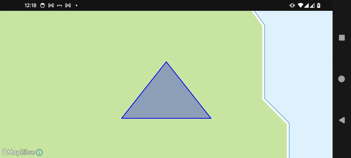
Interactive Polygon with Vertex Markers
@Composablefun InteractivePolygonExample() {    val mapViewState =        rememberMapLibreMapViewState(            cameraPosition =                MapCameraPosition(                    position = GeoPoint.fromLatLong(37.7809, -122.4094),                    zoom = 13.5,                ),        )
    var vertices by remember {        mutableStateOf(            listOf(                GeoPoint.fromLatLong(37.7749, -122.4194),                GeoPoint.fromLatLong(37.7849, -122.4094),                GeoPoint.fromLatLong(37.7799, -122.3994),                GeoPoint.fromLatLong(37.7649, -122.4094)            )        )    }
    val closedVertices = vertices + vertices.first()
    val polygonState = PolygonState(        id = "polygon",  // important        points = closedVertices,        strokeColor = Color.Red,        strokeWidth = 3.dp,        fillColor = Color.Red.copy(alpha = 0.2f),        onClick = { polygonEvent ->            println("Polygon clicked at: ${polygonEvent.clicked} at: ${polygonEvent.clicked}")        }    )
    val onVertexDrag: (MarkerState) -> Unit = { markerState ->        val vertexIndex = markerState.extra as Int        vertices = vertices.toMutableList().apply {            if (vertexIndex < size) {                set(vertexIndex, GeoPoint.from(markerState.position))            }        }    }
    val vertexMarkers = vertices.mapIndexed { index, point ->        MarkerState(            id = "marker-${index + 1}",  // important            position = point,            icon = ColorDefaultIcon(                fillColor = Color.Red,                strokeColor = Color.White,                label = "${index + 1}",                scale = 0.8f            ),            draggable = true,            extra = index,            onDrag = onVertexDrag,        )    }
    MapLibreMapView(        modifier = modifier,        state = mapViewState    ) {        Polygon(polygonState)        vertexMarkers.forEach { marker ->            Marker(marker)        }    }}
Geodesic vs Standard Polygon
@Composablefun MapView(modifier: Modifier = Modifier) {    val mapViewState =        rememberArcGISMapViewState(            cameraPosition =                MapCameraPosition(                    position = GeoPoint(30, 0),                    zoom = 2,                ),        )
    val points =        listOf(            GeoPoint.fromLongLat(23.66, 56.42),            GeoPoint.fromLongLat(13.39, 2.95),            GeoPoint.fromLongLat(-87.82, 38.58),            GeoPoint.fromLongLat(23.66, 56.42),        )
    var marker by remember { mutableStateOf<MarkerState?>(null) }    val onMarkerClick: OnMarkerEventHandler = { markerState ->        marker = markerState    }    val onMarkerDragStart: OnMarkerEventHandler = { markerState ->        println("Started dragging marker: ${markerState.id}")    }    val onMarkerDrag: OnMarkerEventHandler = { markerState ->        println("Dragging marker to: ${markerState.position}")    }    val onMarkerDragEnd: OnMarkerEventHandler = { markerState ->        println("Finished dragging marker: ${markerState.id}")    }    val onPolygonClick: OnPolygonEventHandler = { event ->        marker = MarkerState(            position = event.clicked,            icon = ColorDefaultIcon(                fillColor = event.state.fillColor,                strokeColor = Color.Red,            ),            animation = MarkerAnimation.Drop,            draggable = true,            onClick = onMarkerClick,            onDragStart = onMarkerDragStart,            onDrag = onMarkerDrag,            onDragEnd = onMarkerDragEnd,        )    }
    val polygonState =        remember {            PolygonState(                points = points,                strokeColor = Color.Yellow.copy(alpha = 0.3f),                strokeWidth = 3.dp,                fillColor = Color.Green.copy(alpha = 0.5f),                geodesic = false,                zIndex = 0,                onClick = onPolygonClick,            )        }
    val geodesicPolygonState =        remember {            PolygonState(                points = points,                strokeColor = Color.Red.copy(alpha = 0.3f),                strokeWidth = 3.dp,                fillColor = Color.Blue.copy(alpha = 0.5f),                geodesic = true,                zIndex = 1,                onClick = onPolygonClick,            )        }
    ArcGISMapView(        modifier = modifier,        state = mapViewState,        onMapLoaded = {            println("Map loaded and ready")        },        onMapClick = {            marker = null // Clear selection when the map is clicked        }    ) {
        // Interactive content with markers        Polygon(polygonState)        Polygon(geodesicPolygonState)
        // Show information for the selected marker        marker?.let { markerState ->            Marker(markerState)        }    }}