GroundImage
Una GroundImage es una superposición de imagen posicionada geográficamente en un mapa. Es útil para mostrar planos de plantas, imágenes de satélite, superposiciones meteorológicas o datos basados en imágenes que deben anclarse a coordenadas geográficas específicas.
Función Composable
@Composablefun MapViewScope.GroundImage( bounds: GeoRectBounds, image: Drawable, opacity: Float = 0.5f, id: String? = null, extra: Serializable? = null)@Composablefun MapViewScope.GroundImage(state: GroundImageState)Parámetros
bounds: Límites rectangulares geográficos donde se posiciona la imagen (GeoRectBounds)image: Imagen dibujable para mostrar (Drawable)opacity: Nivel de opacidad de 0.0 (transparente) a 1.0 (opaco) (predeterminado:0.5f)id: Identificador único opcional para la GroundImage (String?)extra: Datos adicionales adjuntos a la GroundImage (Serializable?)
Ejemplos de Uso
GroundImage Básico
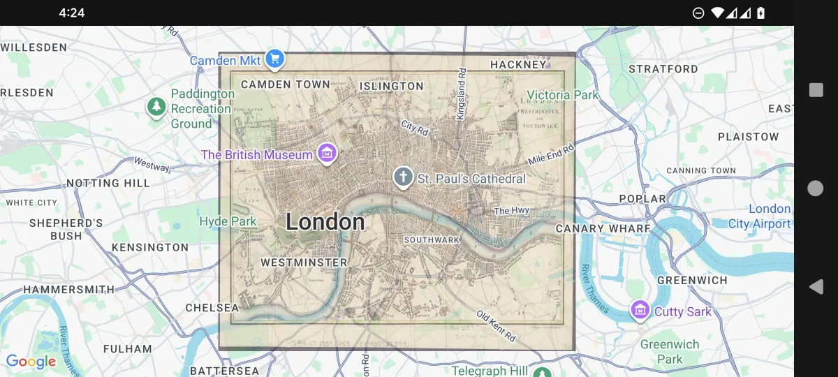
@Composablefun BasicGroundImageExample(    drawable: Drawable,    modifier: Modifier = Modifier,) {    val mapViewState =        rememberGoogleMapViewState(            cameraPosition =                MapCameraPosition(                    position = GeoPoint(51.511649,-0.100761),                    zoom = 12.0,                ),        )
val bounds = GeoRectBounds( southWest = GeoPoint.fromLatLng(51.476747, -0.167729), northEast = GeoPoint.fromLatLng(51.546550,-0.033792), ) GoogleMapView( modifier = modifier, state = mapViewState, ) { GroundImage( id = "groundimage", bounds = bounds, image = drawable, opacity = 0.6f ) }}.jpg)
GroundImage Interactivo con Marcadores de Límites
@Composablefun MapView(    drawable: Drawable,    modifier: Modifier = Modifier,) {    val mapViewState =        rememberGoogleMapViewState(            cameraPosition =                MapCameraPosition(                    position = GeoPoint(51.511649,-0.100761),                    zoom = 12.0,                ),        )
    var marker1 by remember { mutableStateOf(MarkerState(        position = GeoPoint.fromLatLong(51.476747,-0.167729),        draggable = true,    )) }    var marker2 by remember { mutableStateOf(MarkerState(        position = GeoPoint.fromLatLong(51.546550,-0.033792),        draggable = true,    )) }    val bounds = GeoRectBounds(        southWest = marker1.position as GeoPoint,        northEast = marker2.position as GeoPoint,    )    var opacity by remember { mutableStateOf(0.7f) }
    Column(        modifier = modifier,    ) {        Slider(            value = opacity,            onValueChange = { opacity = it },            valueRange = 0f..1f,            modifier = Modifier.padding(16.dp)        )        GoogleMapView(            state = mapViewState,        ) {            Marker(marker1)            Marker(marker2)            GroundImage(                id = "groundimage",                bounds = bounds,                image = drawable,                opacity = opacity            )        }    }}
Manejo de Eventos
Las interacciones de GroundImage se manejan mediante el componente de su proveedor de mapas:
@Composablefun GroundImageEventHandlingExample(overlayImage: Drawable) {    val mapViewState = rememberGoogleMapViewState()
    GoogleMapView(        state = mapViewState    ) {        val imageBounds = GeoRectBounds(            northWest = GeoPoint.fromLatLong(37.8, -122.5),            southEast = GeoPoint.fromLatLong(37.7, -122.4)        )
        GroundImage(            bounds = imageBounds,            image = overlayImage,            opacity = 0.7f,            extra = "Base map overlay",            onClick = { groundImageEvent ->                println("Ground image clicked at: ${groundImageEvent.clicked}")                println("Ground image: ${groundImageEvent.state}")            }        )    }}